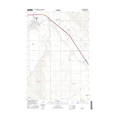
2017 Map of Hardin
USGS Topo · Published 2017About this map
Hardin serves as a focal point of this 2017 survey, showing its established grid at the confluence of transport and water. The town’s relationship with the Bighorn River is clear, with the Big Horn River Bridge connecting the community to the broader Little Bighorn Valley and the southeast-running course of the Little Bighorn River. This landscape is defined by its agricultural and transit infrastructure, featuring the Agency Canal and the presence of E Railroad St and W Railroad St through the heart of the settlement. To the southeast, the small community of Dunmore marks a secondary point of activity. The surrounding terrain is shaped by several distinct drainages including Williams Coulee, Dana Coulee, and Crooked Arm Coulee, which cut through the high ground east of the river valleys.
Find a feature on this map
57 named features on this map. Tap any name to fly to it.
Don’t see what you’re looking for? This feature index may not catch every label — zoom into the map to look around manually.
Map Details
Editions of this 2017 Hardin Map
This is the sole edition of this map. No revisions or reprints were ever made.
Other maps of this area

1894 · Fort Custer
USGS Topo · 1:125,000

1954 · Hardin
USGS Topo · 1:250,000

1957 · Hardin
USGS Topo · 1:250,000

1958 · Hardin
USGS Topo · 1:250,000

1960 · Ninemile Point
USGS Topo · 1:24,000

1960 · Chimney Creek
USGS Topo · 1:24,000

1960 · Walker Hill
USGS Topo · 1:24,000

1960 · Hardin
USGS Topo · 1:24,000
1960 · Prante Ranch
USGS Topo · 1:24,000

1960 · Hardin SW
USGS Topo · 1:24,000