
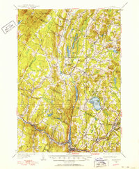
1951 Map of Hardwick
USGS Topo · Published 1972About this map
Hardwick and the surrounding villages of the Northeast Kingdom are captured here in a period of established upland farming and early recreation. The landscape is defined by the Lamoille River and a series of glacial ponds, most notably Caspian Lake, which serves as a centerpiece for the town of Greensboro. A significant historical corridor is visible in the Bayley-Hazen Military Road, a Revolutionary War-era route that helped open this region to settlement. The map reveals a dense network of hill-country communities, from the academic setting of Craftsbury Common to the rail-dependent Greensboro Bend. This survey, based on work from the late 1920s and 1930s, documents the rural infrastructure of the mid-20th century, including numerous local landmarks like the Hazen Road Sch and Hardwick Street, a historic district known for its well-preserved architecture and agricultural legacy.
Find a feature on this map
111 named features on this map. Tap any name to fly to it.
Don’t see what you’re looking for? This feature index may not catch every label — zoom into the map to look around manually.
Map Details
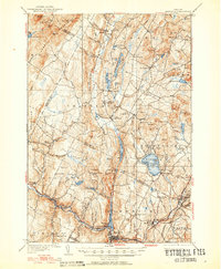
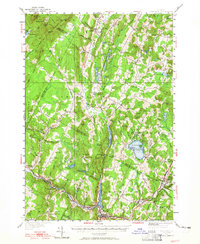
Editions of this 1951 Hardwick Map
4 editions found
Other maps of this area

1919 · Lake Memphremagog
USGS Topo · 1:62,500

1919 · Montgomery
USGS Topo · 1:62,500

1919 · Montpelier
USGS Topo · 1:62,500

1920 · Montgomery
USGS Topo · 1:62,500

1920 · Derby
USGS Topo · 1:62,500

1920 · Irasburg
USGS Topo · 1:62,500

1921 · Montpelier
USGS Topo · 1:62,500

1923 · Irasburg
USGS Topo · 1:48,000

1923 · Lake Memphremagog
USGS Topo · 1:48,000

1925 · Irasburg
USGS Topo · 1:62,500