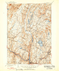
1951 Map of Hardwick
USGS Topo · Published 1952About this map
Hardwick and its surrounding hill towns define this mid-century landscape in the Northeast Kingdom. The area is marked by a legacy of early transport, notably the Bayley Hazen Road and the winding route of the St Johnsbury and Lake Champlain Railroad, which follows the curves of the Lamoille River. The map captures a high density of small rural communities, from the ridge-top elevation of Craftsbury Common to the rail-side activity at Greensboro Bend. Significant water bodies like Caspian Lake and the elongated Eligo Pond are prominent features alongside numerous smaller basins such as Little Hosmer Pond. The distribution of local institutions, including the Hazen Road Sch and Wright Sch, provides a clear view of the social geography before the consolidation of many Vermont mountain districts. Notable terrain features like the Lowell Mountains and Jeudevine Mtn frame the river valleys and upland farms.
Find a feature on this map
111 named features on this map. Tap any name to fly to it.
Don’t see what you’re looking for? This feature index may not catch every label — zoom into the map to look around manually.
Map Details
Editions of this 1951 Hardwick Map
4 editions found
Other maps of this area

1919 · Lake Memphremagog
USGS Topo · 1:62,500

1919 · Montgomery
USGS Topo · 1:62,500

1919 · Montpelier
USGS Topo · 1:62,500

1920 · Montgomery
USGS Topo · 1:62,500

1920 · Derby
USGS Topo · 1:62,500

1920 · Irasburg
USGS Topo · 1:62,500

1921 · Montpelier
USGS Topo · 1:62,500

1923 · Irasburg
USGS Topo · 1:48,000

1923 · Lake Memphremagog
USGS Topo · 1:48,000

1925 · Irasburg
USGS Topo · 1:62,500