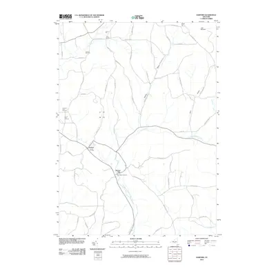
2010 Map of Harford
USGS Topo · Published 2010About this map
Harford and Harford Mills anchor this 2010 landscape in Central New York, where the valley of the East Branch Owego Creek dictates the local geography. The area's agricultural character remains prominent through landmarks like Saltsman Dairy Farm and Jon-Lin Farm, which stand alongside a network of hill roads including Hilsinger Rd and Owego Hill Rd. Genealogists will find a wealth of local-history data in the multiple burial grounds plotted here, from the larger Harford Cemetery to smaller family sites like Carpenter Farm Cemetery and Cornell Lane Cemetery. To the north, the terrain rises toward Virgil Mountain and South Hill, while the western edge is defined by the headwaters of Virgil Creek. The map documents a classic upstate pattern of settlement at the confluence of valley roads and creeks, preserving the exact layout of properties and road networks that have defined this rural community for generations.
Find a feature on this map
54 named features on this map. Tap any name to fly to it.
Don’t see what you’re looking for? This feature index may not catch every label — zoom into the map to look around manually.
Map Details
Editions of this 2010 Harford Map
This is the sole edition of this map. No revisions or reprints were ever made.
Other maps of this area

1898 · Moravia
USGS Topo · 1:62,500

1900 · Dryden
USGS Topo · 1:62,500

1902 · Moravia
USGS Topo · 1:62,500

1903 · Cortland
USGS Topo · 1:62,500

1903 · Harford
USGS Topo · 1:62,500

1906 · Catatonk
USGS Topo · 1:125,000

1942 · Groton
USGS Topo · 1:24,000

1943 · Groton
USGS Topo · 1:31,680

1944 · Cortland
USGS Topo · 1:31,680
1944 · Mc Graw
USGS Topo · 1:31,680