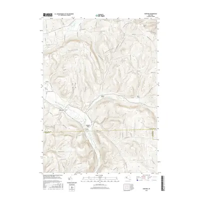
2016 Map of Harford
USGS Topo · Published 2016About this map
Harford Mills and the village of Harford serve as the primary focal points in this 2016 survey of the rolling Finger Lakes region borderlands. Situated where the East Branch Owego Creek begins its southward journey, these settlements are deeply connected to the narrow valleys and steep ridges of the area. The map documents a high density of family-named landmarks and rural infrastructure, including the Harford Cem and the Harford Mills Cem, which provide significant data points for local genealogists. The topography is defined by prominent elevations like Virgil Mtn and the recessed corridors of Babcock Hollow and Quail Hollow. The network of local roads, such as Daisy Hollow Rd and Carpenter Hill Rd, reveals how the modern landscape still follows the historical contours of the creek valleys and upland farm plots.
Find a feature on this map
68 named features on this map. Tap any name to fly to it.
Don’t see what you’re looking for? This feature index may not catch every label — zoom into the map to look around manually.
Map Details
Editions of this 2016 Harford Map
This is the sole edition of this map. No revisions or reprints were ever made.
Other maps of this area

1898 · Moravia
USGS Topo · 1:62,500

1900 · Dryden
USGS Topo · 1:62,500

1902 · Moravia
USGS Topo · 1:62,500

1903 · Cortland
USGS Topo · 1:62,500

1903 · Harford
USGS Topo · 1:62,500

1906 · Catatonk
USGS Topo · 1:125,000

1942 · Groton
USGS Topo · 1:24,000

1943 · Groton
USGS Topo · 1:31,680

1944 · Cortland
USGS Topo · 1:31,680
1944 · Mc Graw
USGS Topo · 1:31,680