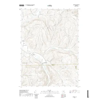
2019 Map of Harford
USGS Topo · Published 2019About this map
Harford and Harford Mills anchor this topographic study of the Southern Tier's high-relief landscape, where the headwaters of the Susquehanna River system begin their descent. The map captures the meeting of three counties—Cortland, Tioga, and Broome—amidst a network of steep ridges and narrow valleys like Griggs Gulf. This area's agricultural and rural heritage is evident in the numerous family-named landmarks and small burial grounds, including the Carpenter Farm Cem and Cornell Lane Cem, which provide valuable location data for genealogists. The drainage patterns are particularly well-defined, showing Virgil Cr flowing north while the First Branch Owego Creek and E Br Owego Cr strike south, illustrating the drainage divide near Virgil Mtn. High-elevation roads like Obrien Hill Rd and Robinson Hollow Rd trace the rugged upland terrain between the valley settlements.
Find a feature on this map
72 named features on this map. Tap any name to fly to it.
Don’t see what you’re looking for? This feature index may not catch every label — zoom into the map to look around manually.
Map Details
Editions of this 2019 Harford Map
This is the sole edition of this map. No revisions or reprints were ever made.
Other maps of this area

1898 · Moravia
USGS Topo · 1:62,500

1900 · Dryden
USGS Topo · 1:62,500

1902 · Moravia
USGS Topo · 1:62,500

1903 · Cortland
USGS Topo · 1:62,500

1903 · Harford
USGS Topo · 1:62,500

1906 · Catatonk
USGS Topo · 1:125,000

1942 · Groton
USGS Topo · 1:24,000

1943 · Groton
USGS Topo · 1:31,680

1944 · Cortland
USGS Topo · 1:31,680
1944 · Mc Graw
USGS Topo · 1:31,680