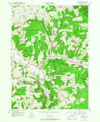
1949 Map of Harford
USGS Topo · Published 1967About this map
The Birthplace of John D Rockefeller sits along the southern edge of this map, marking a site of significant historical interest near the intersection of Michigan Hill and Sears & Woods Road. The landscape is defined by the steep valleys and ridges of the Southern Tier, where the Lehigh Valley railroad cuts through the terrain to serve the primary settlements. Harford and Harford Mills are the principal hubs of activity, situated along the East Branch Owego Creek.
Find a feature on this map
39 named features on this map. Tap any name to fly to it.
Don’t see what you’re looking for? This feature index may not catch every label — zoom into the map to look around manually.
Map Details
Editions of this 1949 Harford Map
This is the sole edition of this map. No revisions or reprints were ever made.
Other maps of this area

1898 · Moravia
USGS Topo · 1:62,500

1900 · Dryden
USGS Topo · 1:62,500

1902 · Moravia
USGS Topo · 1:62,500

1903 · Cortland
USGS Topo · 1:62,500

1903 · Harford
USGS Topo · 1:62,500

1906 · Catatonk
USGS Topo · 1:125,000

1942 · Groton
USGS Topo · 1:24,000

1943 · Groton
USGS Topo · 1:31,680

1944 · Cortland
USGS Topo · 1:31,680
1944 · Mc Graw
USGS Topo · 1:31,680