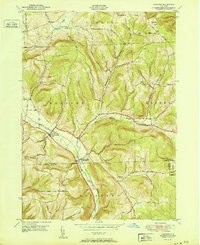
1951 Map of Harford
USGS Topo · Published 1951About this map
Birthplace of John D Rockefeller sits within the rural landscape of southern Cortland County during the mid-twentieth century. This survey documents the topographic character of the Southern Tier region, where the Lehigh Valley railroad cuts through the valley floor, connecting the settlements of Harford and Harford Mills. The terrain is defined by a series of steep ridges and hollows, including Babcock Hollow and Robinson Hollow, with high points such as Virgil Mtn rising above the creek beds.
Find a feature on this map
42 named features on this map. Tap any name to fly to it.
Don’t see what you’re looking for? This feature index may not catch every label — zoom into the map to look around manually.
Map Details
Editions of this 1951 Harford Map
This is the sole edition of this map. No revisions or reprints were ever made.
Other maps of this area

1898 · Moravia
USGS Topo · 1:62,500

1900 · Dryden
USGS Topo · 1:62,500

1902 · Moravia
USGS Topo · 1:62,500

1903 · Cortland
USGS Topo · 1:62,500

1903 · Harford
USGS Topo · 1:62,500

1906 · Catatonk
USGS Topo · 1:125,000

1942 · Groton
USGS Topo · 1:24,000

1943 · Groton
USGS Topo · 1:31,680

1944 · Cortland
USGS Topo · 1:31,680
1944 · Mc Graw
USGS Topo · 1:31,680