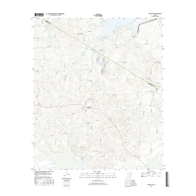
2016 Map of Harleton
USGS Topo · Published 2016About this map
Harleton and Jackson anchor this corner of East Texas, where the landscape transitions from established community centers into the wetlands and water bodies of the Piney Woods. The northern reach of the sheet is defined by the shoreline of Lake O' the Pines, while the southern boundary follows the intricate drainages of Little Cypress Bayou and Moccasin Creek. This 2016 survey records a dense network of local roads such as Old Jefferson Road and Liberty Church Road, which connect numerous rural burial grounds and places of worship. The concentration of sites like Eagle Creek Cemetery, Center Cemetery, and Liberty Church suggests a landscape deeply rooted in family history and early settlement patterns. Modern residential developments are evident at Lake Deerwood and Hope Springs Lake, illustrating how the region's abundant water resources continue to shape local growth and land use.
Find a feature on this map
82 named features on this map. Tap any name to fly to it.
Don’t see what you’re looking for? This feature index may not catch every label — zoom into the map to look around manually.
Map Details
Editions of this 2016 Harleton Map
This is the sole edition of this map. No revisions or reprints were ever made.
Other maps of this area

1956 · Tyler
USGS Topo · 1:250,000

1961 · Hallsville
USGS Topo · 1:24,000

1961 · Lassater
USGS Topo · 1:24,000

1961 · Harleton
USGS Topo · 1:24,000

1962 · Kellyville
USGS Topo · 1:24,000

1962 · Marshall NW
USGS Topo · 1:24,000

1962 · Marshall West
USGS Topo · 1:24,000

1962 · Ashland
USGS Topo · 1:24,000

1962 · Longview Heights
USGS Topo · 1:24,000

1962 · Ore City
USGS Topo · 1:24,000