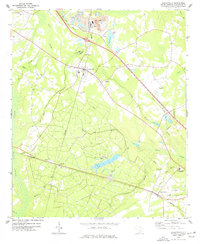
1973 Map of Harleyville
USGS Topo · Published 1977About this map
Harleyville serves as a central hub on this South Carolina landscape, where the Southern railroad line facilitates an industrial corridor of Mine Dumps, Storage Bins, and a Marl Pit. The town layout includes the Jenkins Hill Sch and Mims Academy, surrounded by a network of rural churches such as Mt Zion Ch and Bethlehem Ch. The terrain is defined by the expansive Indian Field Swamp to the west, with numerous drainage systems like Mill Branch and Big Spring Branch feeding into the lowlands. Farther south, the settlement of Pregnall sits along the rail line, near Calvary Ch and St Marks Ch, while the eastern portion of the quadrangle shows the community of Dorchester and its associated Harleyville-Ridgeville High Sch. This 1970s survey captures a moment of established rural infrastructure where traditional country churches and family-named cemeteries exist alongside modern elements like a Golf Course and a series of industrial substations.
Find a feature on this map
45 named features on this map. Tap any name to fly to it.
Don’t see what you’re looking for? This feature index may not catch every label — zoom into the map to look around manually.
Map Details
Editions of this 1973 Harleyville Map
This is the sole edition of this map. No revisions or reprints were ever made.
Other maps of this area

1919 · Ridgeville
USGS Topo · 1:48,000

1920 · Eutawville
USGS Topo · 1:48,000

1920 · Bowman
USGS Topo · 1:48,000

1920 · Ridgeville
USGS Topo · 1:62,500

1920 · St. George
USGS Topo · 1:48,000

1921 · Bowman
USGS Topo · 1:62,500

1921 · St. George
USGS Topo · 1:62,500

1921 · Eutawville
USGS Topo · 1:62,500

1943 · Bowman
USGS Topo · 1:62,500

1943 · Orangeburg
USGS Topo · 1:125,000