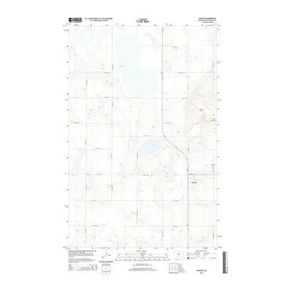
2014 Map of Harlow
USGS Topo · Published 2014About this map
The small settlement of Harlow serves as a central point in this Benson County landscape, situated along the corridor of ND-30. The surrounding terrain is defined by the high elevations of The Buttes to the northeast and a series of glacial depressions that form significant water bodies such as Mud Lake, Sheep Lake, and Twin Lakes. This 2014 survey documents the enduring grid of section roads, including 52nd St NE and 51st Ave NE, which connect the scattered homesteads of this agricultural region. Genealogists may find interest in the location of Our Saviors Cem, positioned north of the townsite. The map illustrates a classic North Dakota prairie landscape where the natural drainage patterns of the lakes dictate the placement of roads and farms, reflecting a century-long relationship between the local geography and rural development.
Find a feature on this map
20 named features on this map. Tap any name to fly to it.
Don’t see what you’re looking for? This feature index may not catch every label — zoom into the map to look around manually.
Map Details
Editions of this 2014 Harlow Map
This is the sole edition of this map. No revisions or reprints were ever made.
Other maps of this area

1953 · Devils Lake
USGS Topo · 1:250,000

1956 · Devils Lake
USGS Topo · 1:250,000

1957 · Comstock
USGS Topo · 1:24,000
1958 · Brinsmade SW
USGS Topo · 1:24,000

1958 · Baker
USGS Topo · 1:24,000

1958 · Harlow
USGS Topo · 1:24,000
1958 · Harlow SE
USGS Topo · 1:24,000
1958 · Harlow SW
USGS Topo · 1:24,000

1971 · Knox
USGS Topo · 1:24,000

1971 · York
USGS Topo · 1:24,000