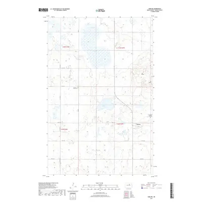
2017 Map of Harlow
USGS Topo · Published 2017About this map
Harlow and its surrounding prairie landscape are defined by a network of seasonal wetlands and glacial depressions typical of the Benson County region. This 2017 survey shows the small settlement positioned along 1st St, serving as a central point for the surrounding agricultural sections. The local heritage is anchored by religious landmarks such as Saint Petri Lutheran Cem to the northwest and Our Saviour Lutheran Church Cem on the eastern edge, reflecting the area's rural community roots. The terrain rises toward the east at The Buttes, while large water bodies like Mud Lake and Sheep Lake dominate the low-lying drainage patterns. A grid of section-line roads, including York Rd and 47th Ave NE, facilitates movement across the township lines of T154N and T155N, connecting the remote farmsteads and cemeteries of the North Dakota plains.
Find a feature on this map
21 named features on this map. Tap any name to fly to it.
Don’t see what you’re looking for? This feature index may not catch every label — zoom into the map to look around manually.
Map Details
Editions of this 2017 Harlow Map
This is the sole edition of this map. No revisions or reprints were ever made.
Other maps of this area

1953 · Devils Lake
USGS Topo · 1:250,000

1956 · Devils Lake
USGS Topo · 1:250,000

1957 · Comstock
USGS Topo · 1:24,000
1958 · Brinsmade SW
USGS Topo · 1:24,000

1958 · Baker
USGS Topo · 1:24,000

1958 · Harlow
USGS Topo · 1:24,000
1958 · Harlow SE
USGS Topo · 1:24,000
1958 · Harlow SW
USGS Topo · 1:24,000

1971 · Knox
USGS Topo · 1:24,000

1971 · York
USGS Topo · 1:24,000