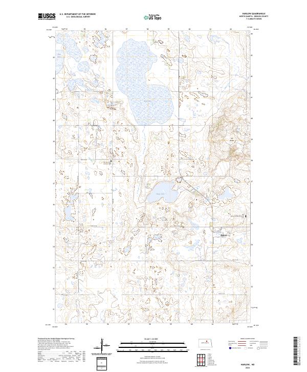
2024 Map of Harlow
USGS Topo · Published 2024About this map
Benson County Waterfowl Production Area dominates the northern and central sections of this landscape, reflecting a commitment to prairie wetland preservation. The small community of Harlow serves as the primary focal point for local navigation, situated near the intersection of 2nd St and 1st St. This area is characterized by numerous small water bodies including Mud Lake, Sheep Lake, and Twin Lakes, which dot the terrain between the sections of the waterfowl refuge. Genealogy interests are supported by the presence of significant local landmarks such as Saint Petri Lutheran Cem and the Our Saviour Lutheran Church Cem further east. The terrain rises slightly at The Buttes, providing a rare topographical variation in this stretch of North Dakota. A grid of rural roads like York Rd and 54th St Ne connects the scattered farmsteads across the township boundaries.
Find a feature on this map
23 named features on this map. Tap any name to fly to it.
Don’t see what you’re looking for? This feature index may not catch every label — zoom into the map to look around manually.
Map Details
Editions of this 2024 Harlow Map
This is the sole edition of this map. No revisions or reprints were ever made.
Other maps of this area

1953 · Devils Lake
USGS Topo · 1:250,000

1956 · Devils Lake
USGS Topo · 1:250,000

1957 · Comstock
USGS Topo · 1:24,000
1958 · Brinsmade SW
USGS Topo · 1:24,000

1958 · Baker
USGS Topo · 1:24,000

1958 · Harlow
USGS Topo · 1:24,000
1958 · Harlow SE
USGS Topo · 1:24,000
1958 · Harlow SW
USGS Topo · 1:24,000

1971 · Knox
USGS Topo · 1:24,000

1971 · York
USGS Topo · 1:24,000