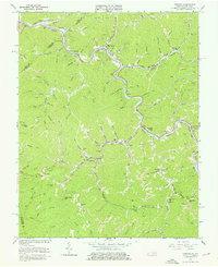
1963 Map of Harman
USGS Topo · Published 1976About this map
Levisa Fork winds through a deeply dissected landscape in Buchanan County, defining the early 1960s industrial and social geography of this coal-producing region. The Norfolk and Western railroad tracks trace the river's edge, serving the numerous strip mines and mine dumps that dominate the mountain slopes. This map captures the integration of mining operations into the rural valley communities, where long conveyor systems bridge the distance between mountain pits and the rail lines below.
Find a feature on this map
92 named features on this map. Tap any name to fly to it.
Don’t see what you’re looking for? This feature index may not catch every label — zoom into the map to look around manually.
Map Details
Editions of this 1963 Harman Map
4 editions found
Other maps of this area

1886 · Grundy
USGS Topo · 1:125,000

1890 · Grundy
USGS Topo · 1:125,000

1892 · Grundy
USGS Topo · 1:125,000

1913 · Clintwood
USGS Topo · 1:62,500

1914 · Bucu
USGS Topo · 1:48,000

1914 · Hurley
USGS Topo · 1:48,000

1915 · Clintwood
USGS Topo · 1:62,500

1915 · Regina
USGS Topo · 1:48,000

1915 · Hurley
USGS Topo · 1:48,000

1916 · Bucu
USGS Topo · 1:62,500