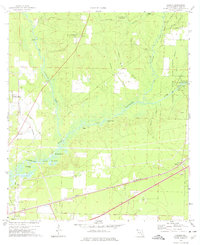
1973 Map of Harold
USGS Topo · Published 1976About this map
Blackwater River and its dense network of tributaries, including Big Coldwater Creek and Juniper Creek, define the geography of this Santa Rosa County landscape. In the early 1970s, the area reflects a balance between military aviation and natural resource management, with the Whiting Field U S Naval Air Sta and Milton T Field occupying the western edge while the Blackwater River State Forest covers the north. Small settlements like Harold and Roeville are linked by the Louisville and Nashville railroad and a highway corridor, while several cemeteries and houses of worship, such as Pleasant Home Ch and Faith Chapel, serve the local population. Significant river-related landmarks like Indian Ford, Race Track Landing, and the Coldwater Lookout Tower indicate a region deeply tied to its waterways and timberlands.
Find a feature on this map
45 named features on this map. Tap any name to fly to it.
Don’t see what you’re looking for? This feature index may not catch every label — zoom into the map to look around manually.
Map Details
Editions of this 1973 Harold Map
2 editions found
Other maps of this area

1920 · Milton
USGS Topo · 1:62,500

1934 · Harold
USGS Topo · 1:62,500

1937 · Harold
USGS Topo · 1:62,500

1938 · Harold
USGS Topo · 1:62,500

1941 · Milton
USGS Topo · 1:62,500

1943 · Milton
USGS Topo · 1:62,500

1943 · Jay
USGS Topo · 1:62,500

1948 · Munson
USGS Topo · 1:62,500

1950 · Munson
USGS Topo · 1:62,500

1957 · Pensacola
USGS Topo · 1:250,000