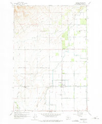
1958 Map of Harrah
USGS Topo · Published 1975About this map
Harrah and Brownstown anchor this mid-century portrait of Yakima County's irrigation-driven agriculture. The landscape is defined by a sophisticated network of water management, including the West Unit Main Canal, East Unit Main Canal, and Highline Canal, which feed numerous numbered laterals and drains. This infrastructure transformed the terrain around Mud Lake and the natural flows of Toppenish Creek and Simcoe Creek into productive farmland. The Northern Pacific railroad cuts through the center of the sheet, connecting the small rail stops of Farron and Venner to the larger regional economy. Evidence of community life is visible at Reservation Memorial Park and the local swimming pool, while the grid of roads named for local families—such as Kays Road, Vogler Road, and Decker Road—illustrates the pattern of rural settlement and property ownership during this era.
Find a feature on this map
54 named features on this map. Tap any name to fly to it.
Don’t see what you’re looking for? This feature index may not catch every label — zoom into the map to look around manually.
Map Details
Editions of this 1958 Harrah Map

Other maps of this area

1899 · Ellensburg
USGS Topo · 1:125,000

1901 · Ellensburg
USGS Topo · 1:125,000

1910 · Zillah
USGS Topo · 1:125,000

1936 · Yakima East
USGS Topo · 1:48,000

1937 · White Swan
USGS Topo · 1:125,000

1941 · Yakima East
USGS Topo · 1:62,500

1950 · Yakima
USGS Topo · 1:250,000

1953 · Yakima East
USGS Topo · 1:24,000
1953 · Yakima East
USGS Topo · 1:62,500

1958 · Toppenish SW
USGS Topo · 1:24,000