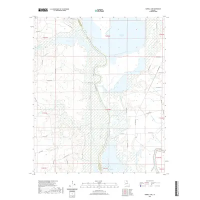
2020 Map of Harrell Lake
USGS Topo · Published 2020About this map
Alabama Lndg sits at the northern reaches of this landscape where the Ouachita River defines the boundary between Union and Morehouse Parishes. This area is characterized by an intricate network of waterways and bottomlands, including Finch Lake and the expansive McGowen Brake. The map reveals a complex system of local transit through the swampy terrain, with numerous specialized routes such as Paw Paw Lake Trl, Spotted Mare Trl, and Boggy Bayou Trl threading between water bodies like Haggerty Camp Lake and Deep Slough Pond. To the southeast, Bayou Bartholomew meanders through the flats, anchoring a region defined by its bayous, creeks, and sloughs. The distribution of parish roads and named trails suggests a landscape where movement was traditionally dictated by the rise and fall of the river and its many tributaries, such as Papaw Bayou and Rossum Bayou.
Find a feature on this map
54 named features on this map. Tap any name to fly to it.
Don’t see what you’re looking for? This feature index may not catch every label — zoom into the map to look around manually.
Map Details
Editions of this 2020 Harrell Lake Map
This is the sole edition of this map. No revisions or reprints were ever made.
Other maps of this area

1935 · Collinston
USGS Topo · 1:62,500

1935 · Naff
USGS Topo · 1:62,500

1935 · Drew
USGS Topo · 1:62,500

1935 · Haile
USGS Topo · 1:62,500

1955 · Jackson
USGS Topo · 1:250,000

1955 · Shreveport
USGS Topo · 1:250,000

1956 · Shreveport
USGS Topo · 1:250,000

1956 · Bastrop
USGS Topo · 1:62,500

1956 · Haile
USGS Topo · 1:62,500

1957 · Monroe North
USGS Topo · 1:62,500