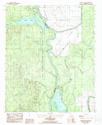
1988 Map of Harrell Lake
USGS Topo · Published 1988About this map
Alabama Landing serves as a focal point for this riverine landscape, where the Ouachita River meanders through the wetlands of the Upper Ouachita National Wildlife Refuge. The map captures a complex network of bayous and brakes typical of the Union and Morehouse Parish border, including Possum Bayou, Miller Bayou, and the expansive McGowen Brake. To the east, the terrain rises toward the Butte de Morancy, contrasting with the low-lying Gas Field and the numerous sloughs that drain into Bayou Bartholomew. The presence of a Pumping Station and named water features like Hooker Hole and Finch Lake illustrates the managed hydrology and natural drainage patterns of this Louisiana floodplain in the late 1980s.
Find a feature on this map
27 named features on this map. Tap any name to fly to it.
Don’t see what you’re looking for? This feature index may not catch every label — zoom into the map to look around manually.
Map Details
Editions of this 1988 Harrell Lake Map
This is the sole edition of this map. No revisions or reprints were ever made.
Other maps of this area

1935 · Collinston
USGS Topo · 1:62,500

1935 · Naff
USGS Topo · 1:62,500

1935 · Drew
USGS Topo · 1:62,500

1935 · Haile
USGS Topo · 1:62,500

1955 · Jackson
USGS Topo · 1:250,000

1955 · Shreveport
USGS Topo · 1:250,000

1956 · Shreveport
USGS Topo · 1:250,000

1956 · Bastrop
USGS Topo · 1:62,500

1956 · Haile
USGS Topo · 1:62,500

1957 · Monroe North
USGS Topo · 1:62,500