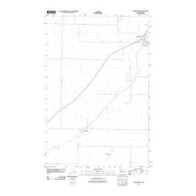
2011 Map of Harrington
USGS Topo · Published 2011About this map
Harrington stands at the northeastern edge of this high-plateau landscape, where the local street grid of W Main St and N Sherlock St gives way to the agricultural expanses of Lincoln County. The winding course of Coal Creek meanders through the territory, cutting through the basalt-inflected terrain toward the small settlement of Mohler in the southwest. This area is characterized by a sparse, purposeful network of ranch roads and farm-to-market routes that trace the section lines, reflecting a century of dryland wheat farming and cattle ranching traditions.
Find a feature on this map
29 named features on this map. Tap any name to fly to it.
Don’t see what you’re looking for? This feature index may not catch every label — zoom into the map to look around manually.
Map Details
Editions of this 2011 Harrington Map
This is the sole edition of this map. No revisions or reprints were ever made.
Other maps of this area

1953 · Ritzville
USGS Topo · 1:250,000

1959 · Ritzville
USGS Topo · 1:250,000

1965 · Ritzville
USGS Topo · 1:250,000

1969 · Rocklyn SW
USGS Topo · 1:24,000

1969 · Bluestem
USGS Topo · 1:24,000

1969 · Harrington
USGS Topo · 1:24,000

1969 · Lords Valley
USGS Topo · 1:24,000

1969 · Cormana Lake
USGS Topo · 1:24,000

1969 · Lamona
USGS Topo · 1:24,000
1969 · Sprague Lake SW
USGS Topo · 1:24,000