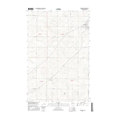
2017 Map of Harrington
USGS Topo · Published 2017About this map
Harrington sits as the primary settlement on this Lincoln County landscape, situated at the intersection of local routes like N 2nd St and S 4th St. The surrounding terrain is defined by the drainage of Coal Creek, which winds through a series of coulees and agricultural tracts. Further south, the settlement of Mohler serves as a waypoint within a grid of family-named farm roads, including Kramer Farms Rd and Buddrius Farms Rd. This area reflects a highly organized rural infrastructure, where long-established range and township lines like t23n r36e dictate the placement of thoroughfares such as Coffee Pot Rd E and Coal Coulee Rd E. The presence of the Kramer Ranch Airport indicates the scale of modern ranching operations in this portion of the Inland Empire, where aviation supports the management of vast grain and livestock holdings.
Find a feature on this map
27 named features on this map. Tap any name to fly to it.
Don’t see what you’re looking for? This feature index may not catch every label — zoom into the map to look around manually.
Map Details
Editions of this 2017 Harrington Map
This is the sole edition of this map. No revisions or reprints were ever made.
Other maps of this area

1953 · Ritzville
USGS Topo · 1:250,000

1959 · Ritzville
USGS Topo · 1:250,000

1965 · Ritzville
USGS Topo · 1:250,000

1969 · Rocklyn SW
USGS Topo · 1:24,000

1969 · Bluestem
USGS Topo · 1:24,000

1969 · Harrington
USGS Topo · 1:24,000

1969 · Lords Valley
USGS Topo · 1:24,000

1969 · Cormana Lake
USGS Topo · 1:24,000

1969 · Lamona
USGS Topo · 1:24,000
1969 · Sprague Lake SW
USGS Topo · 1:24,000