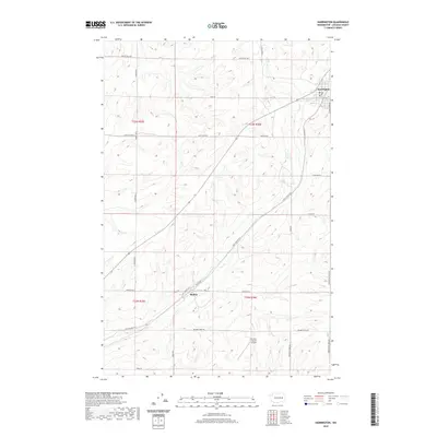
2020 Map of Harrington
USGS Topo · Published 2020About this map
Harrington serves as the primary population center in this section of Lincoln County, characterized by a grid of streets and a central Post Office in the northeast corner of the quadrangle. The surrounding landscape is defined by the coulees and drainage patterns of Coal Creek, which winds through the agricultural heartland of the Palouse. This region is heavily shaped by its farming heritage, evidenced by a dense network of secondary roads such as Kramer Farms Rd and Buddhrius Farms Rd that connect rural homesteads and ranches. To the southwest, the small settlement of Mohler sits near the intersection of Coal Coulee Rd E and Foster Rd. The presence of the Kramer Ranch Airport highlights the importance of private aviation for managing these expansive rural properties in eastern Washington.
Find a feature on this map
27 named features on this map. Tap any name to fly to it.
Don’t see what you’re looking for? This feature index may not catch every label — zoom into the map to look around manually.
Map Details
Editions of this 2020 Harrington Map
This is the sole edition of this map. No revisions or reprints were ever made.
Other maps of this area

1953 · Ritzville
USGS Topo · 1:250,000

1959 · Ritzville
USGS Topo · 1:250,000

1965 · Ritzville
USGS Topo · 1:250,000

1969 · Rocklyn SW
USGS Topo · 1:24,000

1969 · Bluestem
USGS Topo · 1:24,000

1969 · Harrington
USGS Topo · 1:24,000

1969 · Lords Valley
USGS Topo · 1:24,000

1969 · Cormana Lake
USGS Topo · 1:24,000

1969 · Lamona
USGS Topo · 1:24,000
1969 · Sprague Lake SW
USGS Topo · 1:24,000