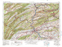
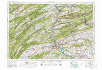
1957 Map of Harrisburg
USGS Topo · Published 1988About this map
Bald Eagle Mountain and Blue Mountain dominate this mid-century view of the Ridge-and-Valley province, where the Susquehanna River cuts through series of parallel ridges. The industrial heart of Central Pennsylvania is visible in the coal-region towns of Shamokin, Mount Carmel, and Ashland, while the agricultural valleys surrounding State College and Harrisburg show the extent of mid-twentieth-century development.
Find a feature on this map
133 named features on this map. Tap any name to fly to it.
Don’t see what you’re looking for? This feature index may not catch every label — zoom into the map to look around manually.
Map Details
Editions of this 1957 Harrisburg Map
7 editions found

Other maps of this area

1889 · Catawissa
USGS Topo · 1:62,500

1889 · Hazleton
USGS Topo · 1:62,500

1889 · Pottsville
USGS Topo · 1:62,500

1891 · Wilkesbarre
USGS Topo · 1:62,500

1891 · Hazleton
USGS Topo · 1:62,500

1891 · Pottsville
USGS Topo · 1:62,500

1891 · Lebanon
USGS Topo · 1:62,500

1892 · Catawissa
USGS Topo · 1:62,500

1892 · Lykens
USGS Topo · 1:62,500

1892 · Hummelstown
USGS Topo · 1:62,500