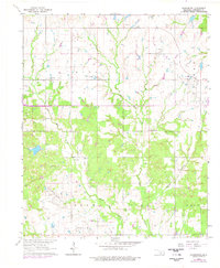
1963 Map of Harrisburg
USGS Topo · Published 1977About this map
Palacine Oil Field and the Northwest Palacine Oil Field dominate this portion of Stephens County, reflecting the deep-rooted energy economy of south-central Oklahoma. The landscape is defined by the dendritic drainage patterns of West Mud Creek and East Mud Creek, which converge south of the small settlement of Harrisburg. The map reveals a rural social infrastructure centered on small community landmarks, including Fairview Ch and the Weaver Chapel complex with its associated Weaver Chapel Cem. The concentration of oil fields, including the West Velma Oil Field near the eastern edge, illustrates how petroleum extraction integrated with existing land use. Revision data from 1976, marked in purple, shows the continued development of roads and industrial sites like the Gravel Pits in the decades following the initial 1960s photogrammetric survey.
Find a feature on this map
18 named features on this map. Tap any name to fly to it.
Don’t see what you’re looking for? This feature index may not catch every label — zoom into the map to look around manually.
Map Details
Editions of this 1963 Harrisburg Map
2 editions found
Other maps of this area

1901 · Addington
USGS Topo · 1:125,000

1902 · Rush Springs
USGS Topo · 1:125,000

1950 · Marlow
USGS Topo · 1:62,500

1951 · Marlow
USGS Topo · 1:62,500

1957 · Ardmore
USGS Topo · 1:250,000

1963 · Ardmore
USGS Topo · 1:250,000

1963 · Harrisburg
USGS Topo · 1:24,000

1964 · Comanche SE
USGS Topo · 1:24,000

1964 · Duncan South
USGS Topo · 1:24,000

1964 · Comanche
USGS Topo · 1:24,000