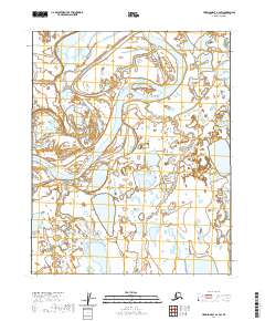
2020 Map of Harrison Bay A-2 SW
USGS Topo · Published 2020About this map
The Colville River dominates this Arctic landscape on the North Slope, where the massive waterway splits into braided channels and expansive wetlands. This 2020 survey illustrates the dynamic hydrology of the region, where the primary river system meets the Itkillik River in a vast delta-like environment. The terrain is defined by a dense network of seasonal ponds and tundra lakes, reflecting the seasonal shifts and water distribution characteristic of this northern territory. Surveyed by the U.S. Geological Survey, the map documents the Colville River as it traverses through the northern reaches of the t9n r4e and t9n r5e townships. The lack of permanent infrastructure or settlements underscores the seasonal and environmental focus of this survey, capturing a specific moment in the shifting Alaskan hydrography.
Find a feature on this map
6 named features on this map. Tap any name to fly to it.
Don’t see what you’re looking for? This feature index may not catch every label — zoom into the map to look around manually.
Map Details
Editions of this 2020 Harrison Bay A-2 SW Map
This is the sole edition of this map. No revisions or reprints were ever made.
Other maps of this area

1951 · Harrison Bay
USGS Topo · 1:250,000

1952 · Umiat
USGS Topo · 1:250,000

1955 · Harrison Bay
USGS Topo · 1:250,000

1955 · Umiat D-2
USGS Topo · 1:63,360

1955 · Harrison Bay A-2
USGS Topo · 1:63,360

1955 · Harrison Bay A-3
USGS Topo · 1:63,360

1955 · Umiat D-3
USGS Topo · 1:63,360

1956 · Umiat
USGS Topo · 1:250,000

1964 · Umiat
USGS Topo · 1:250,000
2013 · Umiat D-3 NE
USGS Topo · 1:25,000