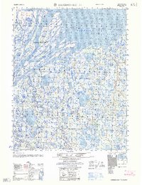
1962 Map of Harrison Bay B-1
USGS Topo · Published 1962About this map
Colville River Delta dominates this coastal survey, where the massive river system fractures into a complex network of braids and distributaries. The landscape is defined by the heavy presence of the Kupiqruak Channel and the Colville River, which carve through the tundra before emptying into the shallow waters of Harrison Bay. Amidst the shifting currents lies Anachlik Island, a prominent landmass within the delta's intricate reach. This 1950s-era photogrammetric compilation by the Army Map Service captures the stark, water-saturated geography of the North Slope, revealing a terrain of endless thermokarst lakes and ponded water typical of the Arctic coastal plain. Precise elevation markers, such as Vabm 10 and Vabm 19, provide the only vertical landmarks across this low-lying expanse of the Beaufort Sea coast.
Find a feature on this map
13 named features on this map. Tap any name to fly to it.
Don’t see what you’re looking for? This feature index may not catch every label — zoom into the map to look around manually.
Map Details
Editions of this 1962 Harrison Bay B-1 Map
This is the sole edition of this map. No revisions or reprints were ever made.
Other maps of this area

1951 · Harrison Bay
USGS Topo · 1:250,000

1951 · Beechey Point
USGS Topo · 1:250,000

1955 · Harrison Bay
USGS Topo · 1:250,000

1955 · Beechey Point
USGS Topo · 1:250,000

1955 · Harrison Bay C-1
USGS Topo · 1:63,360

1955 · Harrison Bay B-2
USGS Topo · 1:63,360

1955 · Harrison Bay B-1
USGS Topo · 1:63,360

1955 · Beechey Point A-5
USGS Topo · 1:63,360
1955 · Beechey Point C-5
USGS Topo · 1:63,360

1955 · Beechey Point B-5
USGS Topo · 1:63,360