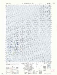
1962 Map of Harrison Bay D-4
USGS Topo · Published 1962About this map
Naval Petroleum Reserve No. 4 dominates the western landscape of this coastal Arctic survey, representing a critical era of cold war resource exploration on Alaska's North Slope. The terrain is characterized by a low-lying, watery expanse where the tundra meets the Beaufort Sea. Notable coastal features include the prominent Cape Halkett, which projects into the shallow waters of Harrison Bay. The map provides a detailed record of the shoreline and bathymetry as they existed in the mid-1950s, captured through photogrammetric methods by the Army Map Service. This record is particularly valuable for researchers tracking coastal erosion and the historical boundaries of the petroleum reserve in this remote permafrost region.
Find a feature on this map
4 named features on this map. Tap any name to fly to it.
Don’t see what you’re looking for? This feature index may not catch every label — zoom into the map to look around manually.
Map Details
Editions of this 1962 Harrison Bay D-4 Map
This is the sole edition of this map. No revisions or reprints were ever made.
Other maps of this area

1951 · Harrison Bay
USGS Topo · 1:250,000

1955 · Harrison Bay
USGS Topo · 1:250,000

1955 · Harrison Bay D-4
USGS Topo · 1:63,360
1955 · Harrison Bay C-3
USGS Topo · 1:63,360

1955 · Harrison Bay C-5
USGS Topo · 1:63,360

1955 · Harrison Bay D-5
USGS Topo · 1:63,360

1955 · Harrison Bay C-4
USGS Topo · 1:63,360

1962 · Harrison Bay C-5
USGS Topo · 1:50,000
1962 · Harrison Bay C-3
USGS Topo · 1:50,000
1962 · Harrison Bay D-5
USGS Topo · 1:50,000