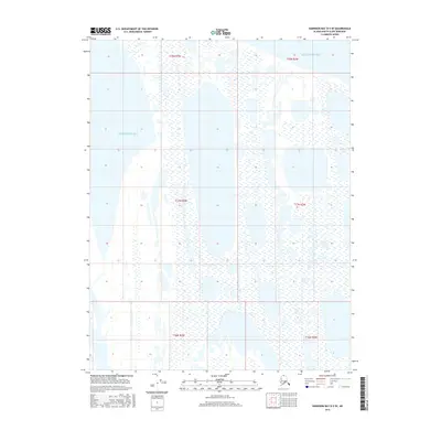
2016 Map of Harrison Bay D-5 SE
USGS Topo · Published 2016About this map
The Beaufort Sea dominates the northern and central portions of this Arctic coastal region in the North Slope Borough. This 2016 survey illustrates the intricate hydrography of the Alaskan shoreline, where land and water merge through a complex network of coastal inlets and wetlands. The landscape is defined by the Public Land Survey System grid, which spans several townships including t18n r3w, t17n r3w, and t16n r3w. These divisions represent the foundational mapping structure for resource management and environmental monitoring in this remote northern latitude. The absence of traditional settlements or roads highlights the seasonal and ecological focus of this coastal map, where the sea and its shifting ice or water levels dictate the character of the terrain.
Find a feature on this map
7 named features on this map. Tap any name to fly to it.
Don’t see what you’re looking for? This feature index may not catch every label — zoom into the map to look around manually.
Map Details
Editions of this 2016 Harrison Bay D-5 SE Map
This is the sole edition of this map. No revisions or reprints were ever made.
Other maps of this area

1951 · Harrison Bay
USGS Topo · 1:250,000

1955 · Harrison Bay
USGS Topo · 1:250,000

1955 · Harrison Bay D-4
USGS Topo · 1:63,360

1955 · Harrison Bay C-5
USGS Topo · 1:63,360

1955 · Harrison Bay D-5
USGS Topo · 1:63,360

1955 · Harrison Bay C-4
USGS Topo · 1:63,360

1962 · Harrison Bay C-5
USGS Topo · 1:50,000
1962 · Harrison Bay D-4
USGS Topo · 1:50,000
1962 · Harrison Bay D-5
USGS Topo · 1:50,000
2013 · Harrison Bay C-5 NW
USGS Topo · 1:25,000