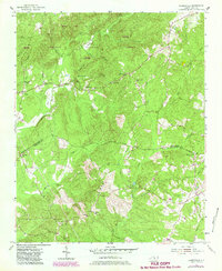
1956 Map of Harrisville
USGS Topo · Published 1983About this map
Uwharrie National Forest and the surrounding woodlands of Montgomery County dominate this mid-century landscape, characterized by a network of creeks and small farming settlements. The village of Harrisville sits near the base of Luther Mtn, marked by the Harrisville Lookout Tower and nearby Sardis Ch. To the south, the terrain descends toward Buffalo Creek and Beaverdam Creek, where the presence of Capels Mill reflects the local water-driven industry of an earlier era.
Find a feature on this map
38 named features on this map. Tap any name to fly to it.
Don’t see what you’re looking for? This feature index may not catch every label — zoom into the map to look around manually.
Map Details
Editions of this 1956 Harrisville Map
3 editions found
Other maps of this area

1942 · Troy
USGS Topo · 1:125,000

1949 · Millstone Lake
USGS Topo · 1:24,000

1949 · Jackson Springs
USGS Topo · 1:62,500

1950 · Norman
USGS Topo · 1:24,000

1953 · Raleigh
USGS Topo · 1:250,000

1954 · Raleigh
USGS Topo · 1:250,000

1956 · Mangum
USGS Topo · 1:24,000

1956 · Mount Gilead East
USGS Topo · 1:24,000

1956 · Ellerbe
USGS Topo · 1:24,000

1956 · Harrisville
USGS Topo · 1:24,000