
1905 Map of Harrodsburg
USGS Topo · Published 1905About this map
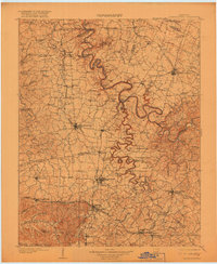
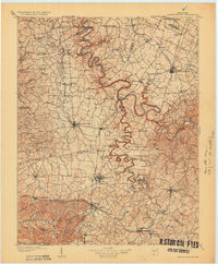
Kentucky River dominates this central Kentucky landscape, carving deep, sinuous bends as it flows past early navigation infrastructure like Lock No 6, Lock No 7, and Lock No 8. The region’s economic lifeblood is clearly visible through its dense railway network, including the Louisville and Nashville RR and the Cincinnati New Orleans and Texas Pacific RR which connect major hubs like Harrodsburg, Danville, and Nicholasville. These lines serviced a mosaic of small farming communities and stops such as Salvisa, Wilmore, and Perryville. The map also captures the intricate watershed of the Dicks River and Salt River, illustrating how topography dictated the placement of historic settlements and transport routes across Mercer, Boyle, and Jessamine counties before the era of modern highway development.
Find a feature on this map
141 named features on this map. Tap any name to fly to it.
Don’t see what you’re looking for? This feature index may not catch every label — zoom into the map to look around manually.
Map Details
Editions of this 1905 Harrodsburg Map
3 editions found
Other maps of this area

1892 · Richmond
USGS Topo · 1:125,000

1893 · London
USGS Topo · 1:125,000

1897 · Richmond
USGS Topo · 1:125,000

1897 · London
USGS Topo · 1:125,000

1906 · Georgetown
USGS Topo · 1:62,500

1908 · Georgetown
USGS Topo · 1:62,500

1922 · Frankfort
USGS Topo · 1:48,000

1923 · Waddy
USGS Topo · 1:48,000

1924 · Frankfort
USGS Topo · 1:62,500

1925 · Mount Eden
USGS Topo · 1:48,000