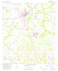
1957 Map of Hartford
USGS Topo · Published 1981About this map
Hartford serves as the central hub of this agricultural landscape in southeastern Alabama, where the city's grid is anchored by City Hall, the County High Sch, and the High Sch. The surrounding countryside reveals a dense network of local institutions essential to rural life in the late 1950s, from Hendrix Crossroad in the north to the small settlement of Black near the southern border. Waterways like Justice Mill Creek and Hurricane Creek drain the area, supporting a land use pattern of scattered farms and small ponds such as McNeil Pond and Daughtry Pond. A significant revision in 1980 introduces a Fish Hatchery east of town, while the presence of the Louisville And Nashville railroad line underscores the historical importance of rail transport to the region's economy. Genealogists will find particular value in the numerous well-documented sites, including Wright Chapel Cem, Fellowship Ch, and the notably abandoned Tate Jr High Sch.
Find a feature on this map
38 named features on this map. Tap any name to fly to it.
Don’t see what you’re looking for? This feature index may not catch every label — zoom into the map to look around manually.
Map Details
Editions of this 1957 Hartford Map
3 editions found
Other maps of this area

1942 · Enterprise
USGS Topo · 1:125,000

1950 · Izagora
USGS Topo · 1:24,000

1950 · Esto
USGS Topo · 1:24,000

1951 · Graceville
USGS Topo · 1:24,000

1951 · Esto
USGS Topo · 1:24,000

1953 · Dothan
USGS Topo · 1:250,000

1954 · Dothan
USGS Topo · 1:250,000

1954 · Tallahassee
USGS Topo · 1:250,000

1955 · Dothan
USGS Topo · 1:250,000

1957 · Malvern
USGS Topo · 1:24,000