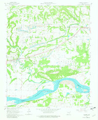
1961 Map of Hartman
USGS Topo · Published 1982About this map
Hartman serves as the primary hub of activity in this 1961 record of Johnson County, situated just north of a prominent bend in the Arkansas River. The landscape reveals a complex history of resource extraction, with numerous strip mines, mine dumps, and gas wells scattered across the Spadra and Prairie townships. This industrial layer is juxtaposed against a deeply rooted community fabric, evidenced by numerous country churches such as Sacred Heart Ch, Hays Chapel, and Union Grove Ch. Transportation patterns are clearly defined by the Missouri Pacific line running east-west through Montana and Hoyt, while an Old Railroad Grade northeast of Hartman hints at earlier transit routes through the river valley. From the heights of Tick Hill to the lowlands of Skaggs Island, the map documents a transitional era where traditional agriculture and coal mining shaped the local economy.
Find a feature on this map
47 named features on this map. Tap any name to fly to it.
Don’t see what you’re looking for? This feature index may not catch every label — zoom into the map to look around manually.
Map Details
Editions of this 1961 Hartman Map
3 editions found
Other maps of this area

1887 · Magazine Mountain #1
USGS Topo · 1:62,500

1887 · Magazine Mountain
USGS Topo · 1:62,500

1888 · Dardanelle #2
USGS Topo · 1:62,500

1889 · Ozone
USGS Topo · 1:62,500

1890 · Magazine Mountain
USGS Topo · 1:125,000

1890 · Dardanelle
USGS Topo · 1:125,000

1906 · Batson
USGS Topo · 1:62,500

1934 · Ozone
USGS Topo · 1:62,500

1936 · Ozone
USGS Topo · 1:62,500

1956 · Russellville
USGS Topo · 1:250,000