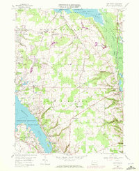
1959 Map of Hartstown
USGS Topo · Published 1972About this map
The Pymatuning Reservoir dominates this landscape, reflecting a mid-century era defined by significant water management and recreation in western Pennsylvania. This survey, updated with 1970 aerial data, reveals the intricate relationship between the sprawling Pymatuning Swamp and the engineered Erie Extension Canal. The settlement pattern centers on rail and road junctions, with small communities like Espyville Station and Hartstown anchoring the rural townships. Genealogists can identify key local landmarks including the Southside Cem and Patton Cem, along with rural institutions like the North Shenango Sch. The presence of the Penn Central and Bessemer and Lake Erie railroads underscores the importance of freight transport through the Shenango valley, while the Twenty-Eighth Division Highway serves as a primary artery connecting Marshall Corners and South Shenango Ch.
Find a feature on this map
35 named features on this map. Tap any name to fly to it.
Don’t see what you’re looking for? This feature index may not catch every label — zoom into the map to look around manually.
Map Details
Editions of this 1959 Hartstown Map
3 editions found

Other maps of this area

1905 · Andover
USGS Topo · 1:48,000

1906 · Linesville
USGS Topo · 1:62,500

1907 · Andover
USGS Topo · 1:62,500

1907 · Kinsman
USGS Topo · 1:62,500

1908 · Shenango
USGS Topo · 1:62,500

1908 · Linesville
USGS Topo · 1:62,500

1950 · Cleveland
USGS Topo · 1:250,000

1956 · Cleveland
USGS Topo · 1:250,000

1958 · Greensville West
USGS Topo · 1:24,000
1958 · Greensville East
USGS Topo · 1:24,000
Featured Places
- Pymatuning Central, PA
- West Fallowfield Township, PA
- Pymatuning South, PA
- Pine Township, PA
- Turner, Pymatuning South