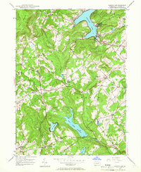
1946 Map of Harveys Lake
USGS Topo · Published 1966About this map
Harveys Lake serves as the focal point of this mid-century survey of Luzerne County, surrounded by a cluster of lakeside communities including Shawanese and Laketon. The landscape transitions from the heights of North Mountain and Kocher Mtn in the northwest to a series of valley settlements and managed water resources. The infrastructure of the era is evident in the presence of the Pikes Creek Reservoir and the Flume near Ceasetown, reflecting the region's hydraulic development. Local history is deeply rooted in the rural landscape, marked by several country schools like Santee Sch and Oakdale Sch, alongside numerous burial grounds such as Maple Grove Cem and Mt Carmel Cem. This documentation captures the area at a point of balance between its natural mountain terrain and the growth of scattered townships like Lehman and Idetown.
Find a feature on this map
44 named features on this map. Tap any name to fly to it.
Don’t see what you’re looking for? This feature index may not catch every label — zoom into the map to look around manually.
Map Details
Editions of this 1946 Harveys Lake Map
5 editions found

Other maps of this area

1891 · Wilkesbarre
USGS Topo · 1:62,500

1891 · Harveys Lake
USGS Topo · 1:62,500

1893 · Harvey Lake
USGS Topo · 1:62,500

1893 · Pittston
USGS Topo · 1:62,500

1894 · Shickshinny
USGS Topo · 1:62,500

1894 · Wilkesbarre
USGS Topo · 1:62,500

1943 · Scranton
USGS Topo · 1:125,000

1946 · Nanticoke
USGS Topo · 1:31,680

1946 · Shickshinny
USGS Topo · 1:31,680

1946 · Kingston
USGS Topo · 1:24,000
Featured Places
- Dallas Township, PA
- Lehman Township, PA
- Harveys Lake, PA
- Hunlock Township, PA
- Pikes Creek, Lake Township