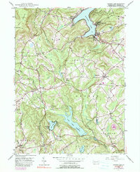
1946 Map of Harveys Lake
USGS Topo · Published 1990About this map
Harveys Lake dominates the northern landscape of this mid-century survey, surrounded by established lakeside communities like Laketon, Shawanese, and Worden Place. The region's hydraulic infrastructure is prominent, featuring the expansive Pikes Creek Reservoir and the surrounding network of Pikes Creek, Harveys Creek, and Bear Hollow Creek. Evidence of earlier transport and industry remains visible through the Old Railroad Grade cutting through the western hills near Kocher Mtn. Local genealogy and community history are well-preserved in the numerous rural burial grounds and educational landmarks, including Maple Grove Cem, St Anns Cem, and the Santee Sch. Small crossroads settlements like Lehman, Idetown, and Silkworth provide a clear view of the settlement patterns in Luzerne County before the suburban expansions of the late twentieth century.
Find a feature on this map
45 named features on this map. Tap any name to fly to it.
Don’t see what you’re looking for? This feature index may not catch every label — zoom into the map to look around manually.
Map Details
Editions of this 1946 Harveys Lake Map
5 editions found

Other maps of this area

1891 · Wilkesbarre
USGS Topo · 1:62,500

1891 · Harveys Lake
USGS Topo · 1:62,500

1893 · Harvey Lake
USGS Topo · 1:62,500

1893 · Pittston
USGS Topo · 1:62,500

1894 · Shickshinny
USGS Topo · 1:62,500

1894 · Wilkesbarre
USGS Topo · 1:62,500

1943 · Scranton
USGS Topo · 1:125,000

1946 · Nanticoke
USGS Topo · 1:31,680

1946 · Shickshinny
USGS Topo · 1:31,680

1946 · Kingston
USGS Topo · 1:24,000
Featured Places
- Dallas Township, PA
- Lehman Township, PA
- Harveys Lake, PA
- Hunlock Township, PA
- Pikes Creek, Lake Township