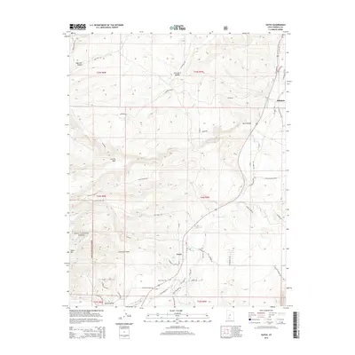
2014 Map of Hatch
USGS Topo · Published 2014About this map
The Sevier River valley serves as the primary corridor through this high-elevation landscape, where the settlement of Hatch stands at the junction of Mammoth Cr and the main river branch. The terrain transition is sharp, rising from the river bottomlands toward the high timber of the Dixie National Forest and the heights of Hatch Mtn. This 2014 survey documents the community of Hillsdale and the local road network that follows natural breaks in the topography, such as Limerock Canyon and Rock Canyon. To the south of the modern town center, Hatch Cem and Old Town Hatch Rd provide clues for genealogists and local historians interested in the earlier footprint of the settlement. The map also records several descriptive landmarks, including the curiously named Graveyard Hollow and Sage Hen Hollow to the north, reflecting the agricultural and natural history of Garfield County.
Find a feature on this map
66 named features on this map. Tap any name to fly to it.
Don’t see what you’re looking for? This feature index may not catch every label — zoom into the map to look around manually.
Map Details
Editions of this 2014 Hatch Map
This is the sole edition of this map. No revisions or reprints were ever made.
Other maps of this area

1886 · Kanab
USGS Topo · 1:250,000

1953 · Cedar City
USGS Topo · 1:250,000

1958 · Cedar City
USGS Topo · 1:250,000

1958 · Panguitch Lake
USGS Topo · 1:62,500

1962 · Cedar City
USGS Topo · 1:250,000

1966 · Wilson Peak
USGS Topo · 1:24,000

1966 · Hatch
USGS Topo · 1:24,000

1966 · George Mtn
USGS Topo · 1:24,000
1966 · Tropic Reservoir
USGS Topo · 1:24,000

1971 · Fivemile Ridge
USGS Topo · 1:24,000