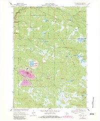
1970 Map of Hatfield SW
USGS Topo · Published 1983About this map
Iron Mound dominates the southwestern terrain of this section of the Black River State Forest, where industrial activity and natural wetlands converge. The landscape is heavily defined by its hydrography, featuring a complex network of impoundments like Staffon Flowage, Teal Flowage, and Schwartz Pool which support the regional ecology. This 1970s survey captures the intersection of land use within the Winnebago Indian Reservation, showing the proximity of tribal lands to heavy extraction sites. Evidence of local industry is clear from the Mining Railroad and a massive Tailings Pond near Bauer, while the remnants of an Old Railroad Grade and Komensky Station mark the former path of timber and ore transport through the Morrison Creek valley.
Find a feature on this map
48 named features on this map. Tap any name to fly to it.
Don’t see what you’re looking for? This feature index may not catch every label — zoom into the map to look around manually.
Map Details
Editions of this 1970 Hatfield SW Map
3 editions found
Other maps of this area

1924 · Black River Falls
USGS Topo · 1:62,500

1926 · Black River Falls
USGS Topo · 1:62,500

1928 · Melrose
USGS Topo · 1:48,000

1947 · Millston
USGS Topo · 1:62,500

1949 · Millston
USGS Topo · 1:62,500

1949 · Melrose
USGS Topo · 1:62,500

1953 · Eau Claire
USGS Topo · 1:250,000

1958 · Eau Claire
USGS Topo · 1:250,000

1958 · Hatfield
USGS Topo · 1:48,000

1964 · Eau Claire
USGS Topo · 1:250,000