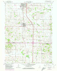
1961 Map of Haubstadt
USGS Topo · Published 1981About this map
Fort Branch and Haubstadt anchor this agricultural landscape in southern Indiana, where the regional economy of the early 1960s is defined by a dense grid of section-line roads and the proximity of the Chicago and Eastern Illinois railroad. The map reveals a transition from the level terrain of the north to the more dissected drainage basins of Hurricane Creek and West Fork Pigeon Creek.
Find a feature on this map
53 named features on this map. Tap any name to fly to it.
Don’t see what you’re looking for? This feature index may not catch every label — zoom into the map to look around manually.
Map Details
Editions of this 1961 Haubstadt Map
Other maps of this area

1901 · Princeton
USGS Topo · 1:62,500

1901 · Haubstadt
USGS Topo · 1:62,500

1902 · Ditney
USGS Topo · 1:125,000

1902 · Boonville
USGS Topo · 1:62,500

1903 · Haubstadt
USGS Topo · 1:62,500

1903 · Petersburg
USGS Topo · 1:62,500

1903 · Princeton
USGS Topo · 1:62,500

1903 · Patoka
USGS Topo · 1:125,000

1956 · Vincennes
USGS Topo · 1:250,000

1957 · Vincennes
USGS Topo · 1:250,000