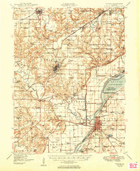
1949 Map of Havana
USGS Topo · Published 1949About this map
The Illinois River corridor near the midpoint of the century is defined by a complex mosaic of industrial extraction and environmental conservation. Heavy Strip Mine operations dominate the northern landscape around Cuba and St David, where the Toledo Peoria and Western RR and several other lines serviced the coal fields. In sharp contrast, the eastern bank is anchored by the Chautauqua National Migratory Waterfowl Refuge, preserving the wetlands of Lake Chautauqua and Quiver Lake from the agricultural encroachment seen elsewhere along the Spoon River.
Find a feature on this map
116 named features on this map. Tap any name to fly to it.
Don’t see what you’re looking for? This feature index may not catch every label — zoom into the map to look around manually.
Map Details
Editions of this 1949 Havana Map
3 editions found
Other maps of this area

1912 · Canton
USGS Topo · 1:62,500

1915 · Avon
USGS Topo · 1:62,500

1918 · Vermont
USGS Topo · 1:62,500

1921 · Vermont
USGS Topo · 1:62,500

1925 · Havana
USGS Topo · 1:62,500

1926 · Beardstown
USGS Topo · 1:62,500

1929 · Manito
USGS Topo · 1:62,500

1930 · Chandlerville
USGS Topo · 1:62,500

1930 · Glasford
USGS Topo · 1:62,500

1932 · Chandlerville
USGS Topo · 1:62,500