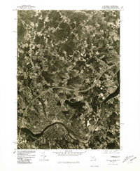
1977 Map of Haverhill
USGS Topo · Published 1981About this map
Merrimack River serves as the dominant geographic anchor for this late 1970s orthophotoquad, winding through the industrial and residential heart of Haverhill and Groveland. The aerial photography, captured in early April 1977, reveals the high-density urban grid of the riverfront before giving way to the expanding suburban developments of Newton, Plaistow, and Merrimac across the Massachusetts and New Hampshire border. Significant natural features like Kenoza Lake are clearly visible, providing a distinct contrast to the emerging highway infrastructure and commercial corridors that defined the region's late-century growth. This survey, produced by the Geological Survey and Soil Conservation Service, offers an unfiltered view of the land use and forested tracts remaining between these historic Merrimack Valley settlements.
Find a feature on this map
7 named features on this map. Tap any name to fly to it.
Don’t see what you’re looking for? This feature index may not catch every label — zoom into the map to look around manually.
Map Details
Editions of this 1977 Haverhill Map
This is the sole edition of this map. No revisions or reprints were ever made.
Other maps of this area

1886 · Lawrence
USGS Topo · 1:62,500

1888 · Newburyport
USGS Topo · 1:62,500

1888 · Haverhill
USGS Topo · 1:62,500

1888 · Lawrence
USGS Topo · 1:62,500

1888 · Salem
USGS Topo · 1:62,500

1890 · Haverhill
USGS Topo · 1:62,500

1890 · Newburyport
USGS Topo · 1:62,500

1893 · Salem
USGS Topo · 1:62,500

1893 · Lawrence
USGS Topo · 1:62,500

1893 · Haverhill
USGS Topo · 1:62,500