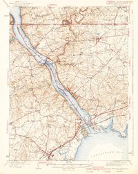
1942 Map of Havre De Grace
USGS Topo · Published 1942About this map
The Susquehanna River dominates this 1940s landscape, serving as both a jurisdictional boundary and a hub of industrial activity. The massive Conowingo Dam and its associated power plant highlight the era's focus on hydroelectric development, while the Mason and Dixon Line defines the northern border with Pennsylvania. To the south, the river opens into the Chesapeake Bay near Havre De Grace, where the Veterans Hospital and a Race Track stand as significant local landmarks.
Find a feature on this map
128 named features on this map. Tap any name to fly to it.
Don’t see what you’re looking for? This feature index may not catch every label — zoom into the map to look around manually.
Map Details
Editions of this 1942 Havre De Grace Map
4 editions found

Other maps of this area

1893 · Gunpowder
USGS Topo · 1:62,500

1898 · Elkton
USGS Topo · 1:62,500

1898 · Tolchester
USGS Topo · 1:125,000

1899 · Dover
USGS Topo · 1:125,000

1900 · Elkton
USGS Topo · 1:62,500

1900 · Cecilton
USGS Topo · 1:62,500

1900 · Havre De Grace
USGS Topo · 1:62,500

1900 · Betterton
USGS Topo · 1:62,500

1901 · Belair
USGS Topo · 1:62,500

1901 · Gunpowder
USGS Topo · 1:62,500