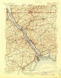
1942 Map of Havre De Grace
USGS Topo · Published 1945About this map
Conowingo Dam and its adjacent Power Plant dominate the upper Susquehanna River corridor, illustrating the industrial transformation of the region just before the mid-20th century. The landscape is a dense network of crossroads settlements and family-named landmarks, ranging from Peach Bottom Beach at the Pennsylvania line to the concentrated street grids of Havre De Grace and Perryville at the mouth of the Chesapeake Bay.
Find a feature on this map
170 named features on this map. Tap any name to fly to it.
Don’t see what you’re looking for? This feature index may not catch every label — zoom into the map to look around manually.
Map Details
Editions of this 1942 Havre De Grace Map
4 editions found

Other maps of this area

1893 · Gunpowder
USGS Topo · 1:62,500

1898 · Elkton
USGS Topo · 1:62,500

1898 · Tolchester
USGS Topo · 1:125,000

1899 · Dover
USGS Topo · 1:125,000

1900 · Elkton
USGS Topo · 1:62,500

1900 · Cecilton
USGS Topo · 1:62,500

1900 · Havre De Grace
USGS Topo · 1:62,500

1900 · Betterton
USGS Topo · 1:62,500

1901 · Belair
USGS Topo · 1:62,500

1901 · Gunpowder
USGS Topo · 1:62,500