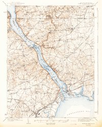
1942 Map of Havre De Grace
USGS Topo · Published 1942About this map
The Susquehanna River dominates this 1940s landscape, serving as the geographic spine for the border region between Maryland and Pennsylvania. Just north of Havre de Grace, the river is bridged by both the Pennsylvania Railroad and the Baltimore and Ohio Railroad, illustrating the area's vital role as a transportation corridor. The massive Conowingo Dam and its adjacent Power Plant represent the era's significant hydroelectric infrastructure. Inland, the map reveals a dense network of early settlements and rural institutions, from the Tome School at Port Deposit to scattered landmarks like Richards Oak and the Mason and Dixon Line along the northern border. Family-named sites like Wilson Mill and Noble Mill sit alongside Numerous country churches, such as St James Ch and Wesleyan Chapel, providing a detailed view of the region's social geography before mid-century expansion.
Find a feature on this map
111 named features on this map. Tap any name to fly to it.
Don’t see what you’re looking for? This feature index may not catch every label — zoom into the map to look around manually.
Map Details
Editions of this 1942 Havre De Grace Map
4 editions found

Other maps of this area

1893 · Gunpowder
USGS Topo · 1:62,500

1898 · Elkton
USGS Topo · 1:62,500

1898 · Tolchester
USGS Topo · 1:125,000

1899 · Dover
USGS Topo · 1:125,000

1900 · Elkton
USGS Topo · 1:62,500

1900 · Cecilton
USGS Topo · 1:62,500

1900 · Havre De Grace
USGS Topo · 1:62,500

1900 · Betterton
USGS Topo · 1:62,500

1901 · Belair
USGS Topo · 1:62,500

1901 · Gunpowder
USGS Topo · 1:62,500