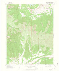
1960 Map of Hawxhurst Creek
USGS Topo · Published 1964About this map
White River National Forest and Grand Mesa National Forest dominate this 1960 landscape, where the high-altitude topography of the Grand Mesa drops into a complex network of gulches and creeks. This era of land use is characterized by seasonal livestock grazing and water management, evidenced by remote outposts like Rincon Cow Camp and Hawxhurst Cow Camp. Essential high-country water resources are marked by the Battlement Reservoirs, Watson Reservoir, and McCurry Reservoir. In the southern portion of the sheet, the terrain levels out near the Salt Plateau and The Peninsula, where Buzzard Creek flows. Local history is anchored by the Clover Cem near the southern boundary, providing a vital point of reference for genealogists tracing early families in this part of Mesa County. The network of Jeep Trails and Pack Trails, such as the Battlement Trail, reveals how the area was navigated before modern infrastructure reached these high elevations.
Find a feature on this map
34 named features on this map. Tap any name to fly to it.
Don’t see what you’re looking for? This feature index may not catch every label — zoom into the map to look around manually.
Map Details
Editions of this 1960 Hawxhurst Creek Map
4 editions found
Other maps of this area

1929 · Grand Valley
USGS Topo · 1:62,500

1955 · Collbran
USGS Topo · 1:24,000

1955 · Molina
USGS Topo · 1:24,000

1955 · The Meadows
USGS Topo · 1:24,000

1956 · Grand Junction
USGS Topo · 1:250,000

1957 · Leadville
USGS Topo · 1:250,000

1959 · Grand Junction
USGS Topo · 1:250,000

1959 · Leadville
USGS Topo · 1:250,000

1960 · Leadville
USGS Topo · 1:250,000

1960 · Grand Junction
USGS Topo · 1:250,000