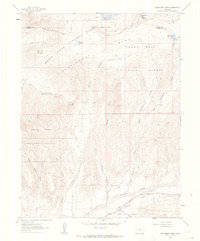
1960 Map of Hawxhurst Creek
USGS Topo · Published 1964About this map
Battlement National Forest and Grand Mesa National Forest dominate this 1960 landscape along the border of Garfield and Mesa counties. The area is defined by its seasonal grazing history, as evidenced by several high-elevation outposts including Kennon Cow Camp, Kimball Cow Camp, and Hawxhurst Cow Camp. These camps, along with the Clover Cem on the Clover Plateau, reflect a pattern of land use centered on the rugged plateaus and creek drainages of the Colorado high country.
Find a feature on this map
31 named features on this map. Tap any name to fly to it.
Don’t see what you’re looking for? This feature index may not catch every label — zoom into the map to look around manually.
Map Details
Editions of this 1960 Hawxhurst Creek Map
4 editions found
Other maps of this area

1929 · Grand Valley
USGS Topo · 1:62,500

1955 · Collbran
USGS Topo · 1:24,000

1955 · Molina
USGS Topo · 1:24,000

1955 · The Meadows
USGS Topo · 1:24,000

1956 · Grand Junction
USGS Topo · 1:250,000

1957 · Leadville
USGS Topo · 1:250,000

1959 · Grand Junction
USGS Topo · 1:250,000

1959 · Leadville
USGS Topo · 1:250,000

1960 · Leadville
USGS Topo · 1:250,000

1960 · Grand Junction
USGS Topo · 1:250,000