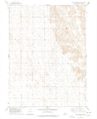
1974 Map of Hayes Center SW
USGS Topo · Published 1977About this map
Blackwood Creek defines the eastern portion of this Hayes County landscape, cutting a deep drainage pattern through the Nebraska plains. This 1974 survey highlights the remote and functional nature of the land during the mid-1970s, where the terrain is marked primarily by scattered infrastructure such as the numerous sites labeled Well. These features, along with the intricate contouring of the uplands, illustrate a region focused on resource management and agricultural necessity. The map provides a precise record of section lines and field boundaries as they existed shortly after the area was mapped by photogrammetric methods in 1973, capturing the rural character of this corner of the state before modern developments or changes in land use occurred.
Find a feature on this map
2 named features on this map. Tap any name to fly to it.
Don’t see what you’re looking for? This feature index may not catch every label — zoom into the map to look around manually.
Map Details
Editions of this 1974 Hayes Center SW Map
This is the sole edition of this map. No revisions or reprints were ever made.
Other maps of this area

1954 · McCook
USGS Topo · 1:250,000

1957 · McCook
USGS Topo · 1:250,000

1958 · McCook
USGS Topo · 1:250,000

1973 · Dittons Creek NE
USGS Topo · 1:24,000

1973 · Suttlers Canyon West
USGS Topo · 1:24,000

1973 · Hayes Center NW
USGS Topo · 1:24,000

1974 · Hamlet
USGS Topo · 1:24,000

1974 · Dittons Creek SE
USGS Topo · 1:24,000

1974 · Hayes Center
USGS Topo · 1:24,000
1974 · Palisade NE
USGS Topo · 1:24,000