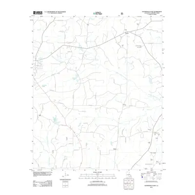
2012 Map of Haynesville East
USGS Topo · Published 2012About this map
Middle Fork Bayou D'Arbonne and its numerous tributaries, including Tiger Cr and Reeder Cr, define the drainage patterns of this Claiborne Parish landscape. The 2012 survey illustrates a region where timber and petroleum interests have long shaped the infrastructure, evidenced by the Northwest Colquitt Oil and Gas Field and the Antlock Lookout Tower. Small settlements like Gordon and Mahan are connected by a network of rural roads such as Winkler Rd and Maddox Rd, while the distribution of family and community burial grounds, including Teague Cem, Old Pine Hill Cem, and New Pine Hill Cem, offers significant data for genealogical research. The presence of Bucktail Camp and numerous named ponds like Callender Pond suggests the enduring importance of local recreation and water management in the upland pine woods.
Find a feature on this map
74 named features on this map. Tap any name to fly to it.
Don’t see what you’re looking for? This feature index may not catch every label — zoom into the map to look around manually.
Map Details
Editions of this 2012 Haynesville East Map
This is the sole edition of this map. No revisions or reprints were ever made.
Other maps of this area

1951 · Summerfield
USGS Topo · 1:62,500

1952 · Homer
USGS Topo · 1:62,500

1953 · El Dorado
USGS Topo · 1:250,000

1955 · Shreveport
USGS Topo · 1:250,000

1956 · Shreveport
USGS Topo · 1:250,000

1957 · El Dorado
USGS Topo · 1:250,000

1958 · El Dorado
USGS Topo · 1:250,000

1960 · El Dorado
USGS Topo · 1:250,000
1971 · Emerson SE
USGS Topo · 1:24,000
1971 · Wesson SW
USGS Topo · 1:24,000