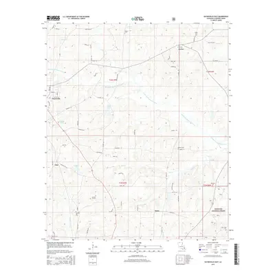
2015 Map of Haynesville East
USGS Topo · Published 2015About this map
Haynesville serves as the primary hub in this corner of Claiborne Parish, where the grid of town streets meets a landscape defined by the winding course of the Middle Fork Bayou D'Arbonne. This 2015 survey reveals a terrain deeply connected to family history and local ancestry, as evidenced by a high density of rural burial grounds such as Teague Cem, Riddle Cem, and Meadows Cem. To the south, the borders of the Kisatchie National Forest emerge near the settlement of Mahan. The map documents a complex network of timber and farm roads, including Red Adams Rd and Graham Ln, which provide access to small water bodies like Campit Lake and Goodwin Lake. For genealogists, the distinction between New Pine Hill Cem and Old Pine Hill Cem offers a specific point of interest for tracing lineage in the community of Oaks.
Find a feature on this map
65 named features on this map. Tap any name to fly to it.
Don’t see what you’re looking for? This feature index may not catch every label — zoom into the map to look around manually.
Map Details
Editions of this 2015 Haynesville East Map
This is the sole edition of this map. No revisions or reprints were ever made.
Other maps of this area

1951 · Summerfield
USGS Topo · 1:62,500

1952 · Homer
USGS Topo · 1:62,500

1953 · El Dorado
USGS Topo · 1:250,000

1955 · Shreveport
USGS Topo · 1:250,000

1956 · Shreveport
USGS Topo · 1:250,000

1957 · El Dorado
USGS Topo · 1:250,000

1958 · El Dorado
USGS Topo · 1:250,000

1960 · El Dorado
USGS Topo · 1:250,000
1971 · Emerson SE
USGS Topo · 1:24,000
1971 · Wesson SW
USGS Topo · 1:24,000