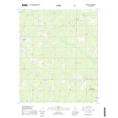
2018 Map of Haynesville East
USGS Topo · Published 2018About this map
Kisatchie National Forest land dominates the southeastern corner of this quadrangle, where the landscape transitions into the riparian corridors of the Middle Fork Bayou D'Arbonne and Bayou D'Arbonne. This 2018 survey captures a rural Claiborne Parish environment defined by scattered settlements like Mahan, Gordon, and Oaks, connected by a dense network of timber and farm roads such as Henry Smith Rd and Graham Ln. The area is notably dense with small family and community burial grounds, including the New Pine Hill Cem, Old Pine Hill Cem, and Gordon Heritage Cem, which offer significant value for genealogical research in this portion of North Louisiana. Water features like Campit Lake and Goodwin Lake provide distinct landmarks among the numerous creeks and ponds that drain the territory.
Find a feature on this map
67 named features on this map. Tap any name to fly to it.
Don’t see what you’re looking for? This feature index may not catch every label — zoom into the map to look around manually.
Map Details
Editions of this 2018 Haynesville East Map
This is the sole edition of this map. No revisions or reprints were ever made.
Other maps of this area

1951 · Summerfield
USGS Topo · 1:62,500

1952 · Homer
USGS Topo · 1:62,500

1953 · El Dorado
USGS Topo · 1:250,000

1955 · Shreveport
USGS Topo · 1:250,000

1956 · Shreveport
USGS Topo · 1:250,000

1957 · El Dorado
USGS Topo · 1:250,000

1958 · El Dorado
USGS Topo · 1:250,000

1960 · El Dorado
USGS Topo · 1:250,000
1971 · Emerson SE
USGS Topo · 1:24,000
1971 · Wesson SW
USGS Topo · 1:24,000