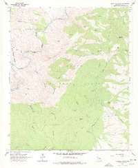
1966 Map of Haystack Butte
USGS Topo · Published 1978About this map
The Salt River carves through the landscape along the northern edge of this Gila County terrain, serving as a natural divider for the Fort Apache Indian Reservation. South of the river, the landscape transitions into the Tonto National Forest, defined by a complex network of drainage systems such as Yankee Joe Canyon and Bronson Canyon. This mid-1960s survey documents a region defined more by its water sources and topography than by permanent settlement, though the presence of the Adobe Ranch and various stock tanks like Black Mesa Tank indicates active land use during the era.
Find a feature on this map
48 named features on this map. Tap any name to fly to it.
Don’t see what you’re looking for? This feature index may not catch every label — zoom into the map to look around manually.
Map Details
Editions of this 1966 Haystack Butte Map
2 editions found
Other maps of this area

1922 · Chrysotile
USGS Topo · 1:125,000

1946 · Blue House Mtn
USGS Topo · 1:62,500

1949 · McFadden Peak
USGS Topo · 1:62,500

1949 · Rockinstraw Mtn
USGS Topo · 1:62,500

1950 · Rockinstraw Mtn
USGS Topo · 1:62,500

1950 · McFadden Peak
USGS Topo · 1:62,500

1951 · Blue House Mtn
USGS Topo · 1:62,500

1954 · Mesa
USGS Topo · 1:250,000

1957 · Mesa
USGS Topo · 1:250,000

1958 · Mesa
USGS Topo · 1:250,000