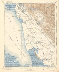
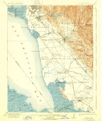
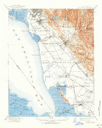
1915 Map of Hayward
USGS Topo · Published 1939About this map
Salt production and rail transport define the East Bay shoreline in the years following the turn of the century. Large operations like the Union City Salt Works and Crystal Salt Works occupy the marshy edges of San Francisco Bay, while a network of landings—including Mulford Landing, Roberts Landing, and Patterson Landing—connects the tidal sloughs to maritime trade. Inland, the landscape transitions from the developed centers of San Leandro and Hayward to the rugged drainage basins of Lake Chabot and the canyon creeks of Castro Valley.
Find a feature on this map
70 named features on this map. Tap any name to fly to it.
Don’t see what you’re looking for? This feature index may not catch every label — zoom into the map to look around manually.
Map Details
Editions of this 1915 Hayward Map
4 editions found

Other maps of this area

1889 · San Jose
USGS Topo · 1:62,500

1892 · San Mateo
USGS Topo · 1:62,500

1895 · San Francisco
USGS Topo · 1:62,500

1896 · San Mateo
USGS Topo · 1:62,500

1896 · Mt. Diablo
USGS Topo · 1:62,500

1897 · San Jose
USGS Topo · 1:62,500

1897 · Concord
USGS Topo · 1:62,500

1897 · Palo Alto
USGS Topo · 1:62,500

1898 · Mt. Diablo
USGS Topo · 1:62,500

1899 · San Jose
USGS Topo · 1:62,500